


- Portada
- volume 13 (2009)
- numéro 2
- An ArcGIS-based tool for the relational data management assistance of Natura 2000 habitat units in the Walloon Region, Belgium


Vista(s): 3857 (27 ULiège)
Descargar(s): 74 (2 ULiège)

An ArcGIS-based tool for the relational data management assistance of Natura 2000 habitat units in the Walloon Region, Belgium

Notes de la rédaction
Received on April 28, 2008, accepted on July 2, 2008
Résumé
Un outil ArcGIS pour l'aide à la gestion des données relationnelles des données d'habitats Natura 2000 en région wallonne (Belgique). La désignation du réseau Natura 2000 repose sur deux directives européennes importantes (79/409/EEC et 92/43/EEC). Chaque état membre est tenu d'établir une liste nationale de sites, opération déjà largement complétée en région wallonne. L'étape suivante consiste à publier des arrêtés de désignation qui précisent ce qui doit être contrôlé et ce qui peut être fait dans chacun des sites. En région wallonne, chaque arrêté doit comprendre une description complète du site et des habitats qui le composent. Un inventaire précis des sites est établi dans ce but. Une cartographie précise des habitats est réalisée à l'aide du SIG ArcGIS alors que, parallèlement, une base de données Access accueille leur description détaillée. Le principal enjeu est de garantir l'intégrité entre les données cartographiques et les données relationnelles qui sont physiquement séparées. La solution proposée ici consiste en une barre d'outils originale intégrée dans l'environnement ArcGIS. Cette barre d'outils propose à l'utilisateur une série de fonctions lui permettant d'établir des liens dynamiques entre ArcGIS et Access. Un outil permet également aux utilisateurs de réaliser des synchronisations entre la cartographie et la base de données.
Abstract
The Natura 2000 network designation stems from two important European conservation directives (79/409/EEC and 92/43/EEC). Each EU member state was instructed to draw up a national list of Natura 2000 conservation sites. This has largely been done. The next step is to specify what action has to be taken and what needs to be controlled in these sites by means of specific designation acts. In the Walloon Region in Belgium, the designation acts have to include a full description of the site and the habitats composing it. For this purpose, field biologists have been making a detailed inventory of all Natura 2000 sites. Land use and habitats are mapped into a Geographic Information System (ArcGIS) and a full description of them (including information needed to describe conservation states) is stored in a relational database (Access). The main problem is ensuring data integrity between the cartographic and database systems, which are completely separate. The technical solution that has been developed is an original set of tools integrated into the ArcGIS interface. These tools offer a variety of functions that enable users to create dynamic links between ArcGIS and Access. A tool will also carry out batch synchronization between the two systems.
1. Introduction
1The Natura 2000 program is part of the strategy set out in 1992 in the Fifth European Community Program of Policy and Action in relation to the Environment and Sustainable Development. Biodiversity conservation is a major theme in this program. It is expressed in two important directives:
2– Council Directive 79/409/EEC on the conservation of wild birds (EEC, 1979),
3– Council Directives 92/43/EEC and 97/62/EEC on the conservation of natural habitats and of wild fauna and flora (EEC, 1992).
4Belgium, like other European Community member states, has drawn up its national list of "Natura 2000" sites. The Walloon Region has selected 240 sites to include in its Natura 2000 network. They cover 221,000 ha, which is 13% of the Walloon Region area. The next step is to officialize the Natura 2000 sites by promulgating a designation act for each of them that includes the following main items (Bottin et al., 2005):
5– an accurate map of habitats of community of interest for which the site has been selected,
6– an evaluation of the populations of species of community of interest for which the site has been selected,
7– a statement of the management objectives for the site,
8– a statement of the measures to be applied in and around the site to prevent significant deterioration of habitats and perturbation of species.
9The preparation of designation acts needs much inventory field work and requires appropriate tools for collecting, organizing and analyzing habitat data. Bottin et al. (2005) present the methodology used for carrying out the inventory and mapping of habitat units. Cartographic data are stored in the ArcGIS Geographic Information System, and all the information for their description are stored in an Access relational database. ArcGIS can hold relational data in its "Personal Geodatabases", but the two entities had to be kept separate for several reasons:
10– the users work in teams generally composed of two people, one in charge of the mapping task and the other one of the database,
11– a powerful and productive tool is needed to generate forms and reports, and especially to analyze the conservation state. Access is very convenient and effective for such tasks,
12– it must be possible to use the relational database separately from the cartographic data,
13– the current database standard in use in public administration is Access 97, but personal geodatabases are stored in Access 2000 files.
14The problem we faced was to create a dynamic link between the ArcGIS and Access data and to keep the integrity between the two systems. Here we describe a solution to this important problem.
2. Material and methods
15The Walloon Natura 2000 habitat description methodology is described in an unpublished user's manual drafted by Dufrêne et al. (2006). The manual explains how to recognize and characterize each habitat unit in the field. Each habitat unit receives a specific field code and is described by the habitat or habitat complex that composes it according to a version of the European Nature Information System (EUNIS) (Davies et al., 2004) typology adapted to Walloon habitats.
16Field biologists have to fill out several forms appropriate to the main types of habitat. Each form records information about habitat composition, structure and perturbation for each habitat unit, which are qualified criteria for conservation state evaluation. This data collection is based on a full inventory of the habitat units in open fields, transects along water courses and numerous small sampling units in large forest habitats. The information are completed by full vegetation records.
17The main purpose of recording these variables is to obtain a detailed description of each habitat unit to evaluate its conservation state as accurately as possible at the local level and also at site scale by combining unit values for the same habitat. These precise information will be used to measure habitat quality, which depends upon:
18– composition (integrity of species assemblage, number of characteristic species, etc.),
19– structure (surface, connectivity, vertical and horizontal stratification, diversity of states, dead wood quality and quantity, etc.).
20It will also be used to evaluate the impact of perturbations. For each habitat type, several indicators are used and threshold values are set to evaluate their quality. The conservation state of the habitat unit is expressed by a combination of the different quality values of the indicators.
21Habitats are modeled as polygons, lines or points depending on the area they cover. In the field, they are manually delineated on geographic maps. Positioning is helped by portable GPS units.
22Habitat mapping is achieved using Environmental System Research Institute ArcGIS 9.1 software. Layers are saved as polygons, lines or points under the same dataset in a personal geodatabase. Datasets are defined with the "Belge Lambert 1972" coordinates reference system. The digitization process is facilitated by the use of ortho-rectified vertical aerial photographs, 1/10,000 topographic maps and coordinates recorded with a field GPS.
23Information concerning each habitat unit are saved in a MS Access 97 relational database. This database contains up to 41 tables, 36 relation rules between tables and 389 different fields. Dedicated forms help the users in inputting all habitat data.
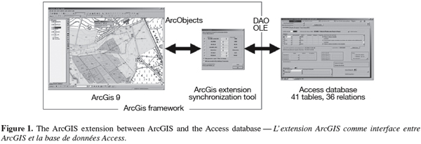
24The Natura 2000 extension for ArcGIS 9 is an ActiveX DLL written in Visual Basic 6. The DLL intensively uses the objects accessible through the ArcObjects interface (Zeiler, 2001; Burke, 2003). MS Object Linking and Embedding (OLE) and MS Database Object Library 3.51 are used to communicate with the MS Access database. Structured Query Language (SQL) is used to retrieve data from the Access database. Intensive use is made of the Microsoft Component Object Model (COM) technology (Lewis, 1999). COM is a standard or protocol that connects one software component or module to another. With this protocol it is possible to build reusable software components that can be dynamically interchanged in a distributed system (Figure 1).
3. The developed tool
25The data acquisition scheme can be described as follows:
26– After the field work has been completed, the operator digitizes the new features in one of the 3 appropriate feature classes (point, line, polygon). Each feature represents one habitat unit. The 3 feature classes are grouped in a feature dataset. There is one dataset per Natura 2000 site.
27– The user enters the main descriptive variables of each habitat unit into the attributes table of the corresponding ArcGIS feature class.
28– The user completes the habitat unit database with all the variables recorded during the field sessions (variables concerning the habitat unit and also vegetation records, etc.).
29The aim of the tool is to ensure that the integrity between the mapping features and the database records is maintained. This is done by establishing a connection between ArcGIS and the Access database.
30The developed tool takes the form of customized toolbar in ArcGIS 9.1 (Figure 2). The "Natura 2000 toolbar" offers the user, who has to encode maps and database data, several functions. Some of these functions enable the user to maintain the integrity between the cartography and database, while other functions help to perform usual GIS tasks not easily accessible under ArcGIS 9 (surface computing, attribute exporting in the Access mdb format, geodatabase creation from ArcMap, etc.).
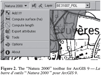
31After installing the toolbar, the user has to set the path to the underlying Access database. This setting is saved in the registry, to be recalled at each use of the extension. During a mapping session, the user chooses the active habitat layer in a dropdown list displayed on the toolbar. It is then possible to use the "Natura 2000" tool (small arrow in figure 2) to click on features of the selected layer. When a feature is found, an edit input form is displayed so the user can directly enter the habitat unit's attributes (Figure 3).
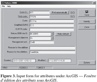
32Three variables are mandatory and must be filled out by the user:
33– the specific field code given by the user in the field,
34– the Natura 2000 site code,
35– a specific identifier.
36The field code is a mnemonic code given by the user who is responsible for its increment. The specific identifier can be assigned automatically by the tool; it consists of a sequential number. The two indicators marked "BD" inform the user if the Code_ID and Field_Code values already exist or not into the database. They appear in red if not and in green if they are already used in the database. The user can then not only fill in the form with other variables and save it, but also copy the form content to the underlying Access database specified in the option window. Before copying it to the database, the extension first checks whether there is a record concerning the present habitat unit (the SQL query is then based on 3 fields: the specific code given to the feature, the Natura 2000 site code and the feature layer type involved). If no record is found, then the extension performs a second search with the specific field code given by the user (this second query is based on 3 fields: specific field code, Natura 2000 site code and feature layer type involved). If no record is found after these 2 queries, the tool invites the user to create a new record in the Access database. If the user agrees, a new record is created and the feature's attributes are then copied into the database.
37When information are entered in both the ArcGIS attribute table and the Access database, the edit window can also be used to create a dynamic link to the Access database. This automatic link is made by Microsoft Automation technology, which allows the tool to instantiate a Microsoft Access database object and manipulate it via its properties and functions. The user can actuate the link by clicking on the GIS feature code or the specific field code (underlined fields in figure 3). After clicking, Access displays the habitat units form filtered on the current habitat units so the user can enter all the other variables stored in the relational database.
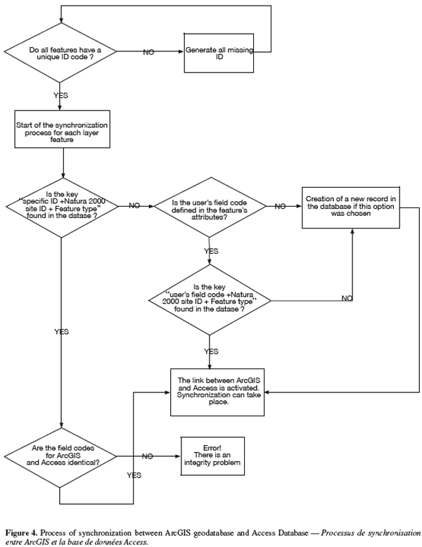
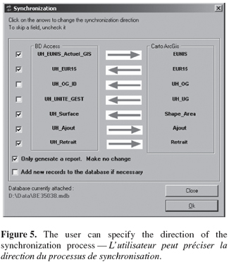
38The ArcGIS extension can also be used as a batch synchronization tool. This allows the user to feed the ArcGIS geodatabase and the Access relational database separately. A common scenario occurs when a field team is composed of two people: one working on the ArcGIS layers and the other one on the Access database. For the synchronization process, the tool uses the algorithm presented in figure 4. The user can specify the direction of the synchronization for several fields of the feature layer (Figure 5).
39The extension offers other user functions. One enables the user to create geodatabases, datasets and feature classes directly within ArcMap user interface. Datasets are created with the appropriate coordinates reference system and XY extent. Similarly, feature classes are created with standardized Natura 2000 attributes. Another function offered by the extension is the export of attribute tables directly to Microsoft Access tables (MDB files).
40The tool offers also the possibility to enter species data into the selected database via ArcMap. The user establishes a selection of features for a given feature class, selects the species name from a dropdown list, sets a number of parameters (e.g. reproduction state, last observation year, etc.) and than is able to update the database. It is also possible for the user, thanks to the developed tool, to perform a features selection based on species information contained in the database.
4. Conclusion
41Precise description of geographic features often requires using a Relational Database Management System (RDBMS) because of the intrinsic relational nature of the data. However, geographic information systems (GIS) do not provide all the features offered by relational RDBMS. In the Walloon region of Belgium, ESRI ArcGIS is used to monitor the Natura 2000 habitat unit mapping. ArcGIS features layers are linked to a single attribute table, making them unsuitable for managing the relational data needed to fully describe the habitat units. Also, the users must be able to manipulate habitat unit data separately from the GIS infrastructure. The problem is to preserve the integrity between cartographic and relational data, which are physically separate. This is achieved using an original ArcGIS extension that offers the user a new toolbar in the ArcGIS environment. This toolbar was developed in Visual Basic 6 using COM technology to create the link between ArcGIS and the Access database. ESRI ArcObjects is used to interface ArcGIS and the toolbar, while DAO and OLE are used to interface the toolbar and the Access database. The link between ArcGIS features and Access records is activated with a 3-key system:
42– the Natura 2000 site ID,
43– the feature type (polygon, line or point),
44– a specific ID proper to the feature layer and given by the tool.
45By means of this toolbar, the users are able to enter feature attributes into a dedicated form, copy feature attributes to the Access database and perform batch synchronization between ArcGIS layers and Access database. The system has now been used for one year by 7 different field crews and has proved its reliability.
46Acknowledgements
47This work was carried out as part of a project funded by the Walloon Region authority (DGRNE/DNF). We are grateful to all those at the "Centre de Recherche de la Nature, des Forêts et du Bois" (CRFNB) who have helped in the development of the proposed tool. We also thank Guy-Alain Ambé who developed the first version of the database dedicated to the Natura 2000 habitat units.
Bibliographie
Bottin G., Etienne M., Verté P. & Mahy G., 2005. Methodology for the elaboration of Natura 2000 sites designation acts in the Walloon Region (Belgium): calcareous grasslands in the Lesse-and-Lomme area. Biotechnol. Agron. Soc. Environ., 9(2), 101-110.
Burke R., 2003. Getting to Know ArcObjects. Redlands, CA, USA: ESRI Press.
Davies C.E., Moss D. & Hill M.O., 2004. EUNIS Habitat Classification, Revised 2004. Report to European Environment Agency, European Topic Centre on Nature Protection and Biodiversity.
Dufrêne M. & Delescaille L.-M., 2006. Guide méthodologique pour l'inventaire et la cartographie des habitats et des habitats d'espèces dans le cadre de la réalisation des arrêtés de désignation en Région wallonne. Version 6, mars 2006. Gembloux, Belgique : Centre de Recherche de la Nature, des Forêts et du Bois.
EEC, 1979. Council Directive of 2 April 1979 on the conservation of wild birds (79/409/EEC). Off. J. Eur. Communities, L103, 25/4/1979, 1.
EEC, 1992. Council Directive 92/43/EEC of 21 May 1992 on the conservation of natural habitats and of wild fauna and flora. Off. J. Eur. Communities, L206, 22/07/92, 7.
Lewis T., 1999. VB COM. Birmingham, UK: Wrox Press.
Zeiler M., 2001. Exploring ArcObjects. Redlands, CA, USA: ESRI Press.
Para citar este artículo
Acerca de: Yvan Barbier
Gembloux Agricultural University – FUSAGx. Unit of Forest and Nature Management. Passage des Déportés, 2. B-5030 Gembloux (Belgium). E-mail: y.barbier@mrw.wallonie.be – Research Center of Nature, Forests and Wood. Avenue de la Faculté, 22. B-5030 Gembloux (Belgium).
Acerca de: Philippe Lejeune
Gembloux Agricultural University – FUSAGx. Unit of Forest and Nature Management. Passage des Déportés, 2. B-5030 Gembloux (Belgium).
Acerca de: Marc Dufrêne
Research Center of Nature, Forests and Wood. Avenue de la Faculté, 22. B-5030 Gembloux (Belgium).
Acerca de: Jacques Rondeux
Gembloux Agricultural University – FUSAGx. Unit of Forest and Nature Management. Passage des Déportés, 2. B-5030 Gembloux (Belgium).